|
Carroll County IAGenWeb |
of
GREENE and CARROLL COUNTIES, IOWA
The Lewis Publishing Company, 1887
Transcribed by Sharon Elijah February 15, 2021
|
|
Carroll County IAGenWeb |
Transcribed by Sharon Elijah February 15, 2021
Geologists divide the soil of Iowa into three general divisions, which not only possess different physical characters, but also differ in the mode of their origin. These are drift, bluff and alluvial and belong respectively to the deposits bearing the same names. The drift occupies a much larger part of the surface of the State than both the others. The bluff has the next greatest area of surface.All soil is disintegrated rock. The drift deposit of Iowa was derived to a considerable extent from the rocks of Minnesota; but the greater part was derived from its own rocks, much of which has been transported but a short distance. In Northern and Northwestern Iowa the drift contains more sand and gravel than elsewhere. In Southern Iowa the soil is frequently stiff and clayey. The bluff soil is found only in the western part of the State, and adjacent to Missouri River. Although it contains less than 1 per cent of clay in its composition, it is in no respect inferior to the best drift soil. The alluvial soil is that of the flood plains of the river valleys, or bottom lands. That which is periodically flooded by the rivers is of little value for agricultural purposes; but a large part of it is entirely above the reach of the highest flood, and is very productive.
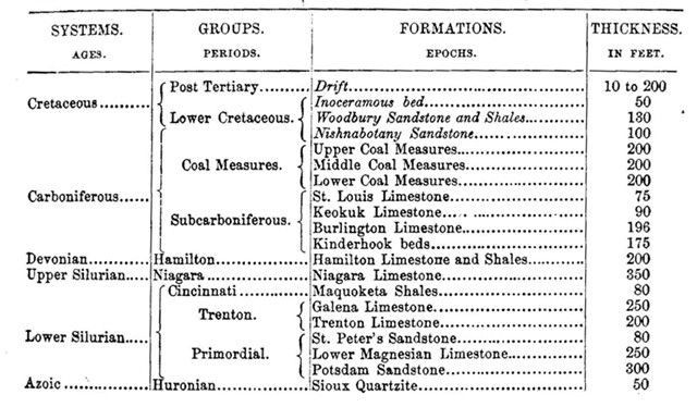
The stratified rocks of Iowa range from the Azoic to the Mesozoic, inclusive; but the greater portion of the surface of the State is occupied by those of Palćozoic age. The table below will show each of these formations in their order:
The Sioux quartzite, in the azoic system, is found exposed in natural ledges only upon a few acres in the extreme northwest corner of the State, upon the banks of the Big Sioux River, for which reason the specific name of Sioux quartzite has been given them. It is an intensely hard rock, breaks in splintery fracture, and of a color varying, in different localities, from a light to deep red. The process of metamorphism has been so complete throughout the whole formation that the rock is almost everywhere of uniform texture. The dip is four or five degrees to the northward, and the trend of the outcrop is eastward and westward.
The Potsdam sandstone formation is exposed only in a small portion of the northeastern part of the State. It is only to be seen in the bases of the bluffs and steep valley sides which border the river there. It is nearly valueless of economic purposes. No fossils have been discovered in this formation in Iowa.
The Lower Magnesian limestone has but little greater geographical extent in Iowa than the Potsdam sandstone. It lacks a uniformity of texture and stratification, owing to which it is not generally valuable for building purposes.
The St. Peter’s sandstone formation is remarkably uniform in thickness throughout its known geographical extent, and it occupies a large portion of the northern half of Allamakee County; immediately beneath the drift.
With the exception of the Trenton lime-stone, all the limestones of both Upper and Lower Silurian age in Iowa are magnesian limestone. This formation occupies large portions of Winneshiek and Allamakee counties, and a small part of Clayton. The greater part of it is useless for economic purposes; but there are some compact, even layers that furnish fine material for window caps and sills.
The Galena limestone is the upper formation of the Trenton Group. It is 150 miles long and seldom exceeds twelve miles in width. It exhibits its greatest development in Dubuque County. It is nearly a pure dolomite with a slight admixture of siliceous matter; good blocks for dressing are sometimes found near the top of the bed, although it is usually unfit for such a purpose. The formation is the source of the lead ore of the Dubuque lead mines. The lead region proper is confined to an area of about fifteen miles square in the vicinity of Dubuque. The ore occurs in vertical fissures, which traverse the rack at regular intervals from east to west; some is found in those which have a north and south direction. This ore is mostly that known as galena, or sulphuret of lead, very small quantities only of the carbonate being found with it.
The surface occupied by the Maquoketa shales is more than 100 miles in length, but is singularly long and narrow, seldom reaching more than a mile or two in width. The most northern exposure yet recognized is in the western part of Winneshiek County, while the most southerly is in Jackson County, in the bluffs of the Mississippi. The formation is largely composed of bluish and brownish shales, sometimes slightly arenaceous, sometimes calcareous, which weather into a tenacious clay upon the surface, and the soil derived from it is usually stiff and clayey.
The area occupied by the Niagara limestone is forty and fifty miles in width and nearly 160 miles long from north to south. This formation is entirely a magnesian limestone, with a considerable portion of silicious matter, in some places, in the form of chert or coarse flint. A large part of it probably affords the best and greatest amount of quarry rock in the State. The quarries at Anamosa, Le Claire and Farley are all opened in this formation.
The area of surface occupied by the Hamilton limestone and shales, is as great as those by all the formations of both Upper and Lower Silurian age in the State. Its length is nearly 200 miles, and width from forty to fifty. Portions of it are valuable for economic purposes; and, having a large geographical extent in the State, is a very important formation. Its value for the production of hydraulic lime has been demonstrated at Waverly, Bremer County. The heavier and more uniform magnesian beds furnish material for bridge piers and other material requiring strength and durability. A coral occurs near Iowa City, known as “Iowa City marble” and “bird’s-eye marble.”
Of the three groups of formations that constitute the carboniferous, viz., the subcarboniferous, coal measures and Permian, only the first two are found in Iowa.
The Subcarboniferous group occupies a very large area of surface. Its eastern border passes from the northeastern part of Winnebago County, with considerable directness in a southeasterly direction to the north part of Washington County. It then makes a broad and direct bend nearly eastward, striking the Mississippi at Muscatine. The southern and western boundaries are to a considerable extent the same as that which separates it from the real field. From the southern part of Pocahontas County is passes southeast to Fort Dodge, thence to Webster City, then to a point three or four miles northeast of Eldora, in Hardin County, thence southward to the middle of the north line of Jasper County, thence southeastward to Sigourney, in Keokuk County, thence to the northeastern corner of Jefferson County, thence sweeping a few miles eastward to the southeast corner of Van Buren County. Its arc is about 250 miles long and from twenty to fifty miles wide.
The most southerly exposure of the Kinderhook beds is in Des Moines County, near the mouth of Skunk River. The most northerly now known is in the eastern part of Pocahontas County, more than 200 miles distant. The principal exposures of this formation are along the bluffs which border the Mississippi and Skunk rivers, where they form the eastern and northern boundary of Des Moines County; along English River, in Washington County; along the Iowa River, in Tama, Marshall, Hamlin and Franklin counties, and along the Des Moines River, in Humboldt County. This formation has a considerable economic value, particularly in the northern portion of the region it occupies. In Pocahontas and Humboldt counties it is invaluable, as no other stone except a few boulders are found here. At Iowa Falls the lower division is very good for building purposes. In Marshall County all the limestone to be obtained comes from this formation, and the quarries near Le Grand are very valuable. At this point some of the layers are finely veined with peroxide of iron, and are wrought into both useful and ornamental objects. In Tama County the oolitic member is well exposed, where it is manufactured into lime. Upon exposure to atmosphere and frost it crumbles to pieces; consequently it is not valuable for building purposes.
The Burlington limestone is carried down by the southerly dip of the Iowa rocks, so that it is seen for the last time in this State in the valley of Skunk River, near the southern boundary of Des Moines County; it has been recognized in the northern part of Washington County, which is the most northerly point that it has been found; but it probably exists as far north as Marshall County. Much valuable material is afforded by this formation for economic purposes. The upper division furnishes excellent common quarry rock. Geologists are attracted by the great abundance and variety of its fossils — crinoids — now known to be more than 300.
The Keokuk limestone formation is to be seen only in four counties: Lee, Van Buren, Henry and Des Moines. In some localities the upper silicious portion is known as the Geode bed; it is not recognizable in the northern portion of the formation, nor in connection with it where it is exposed, about eighty miles below Keokuk. The geodes of the Geode bed are more or less masses of silex, usually hollow and lined with crystals of quartz; the outer crust is rough and unsightly, but the crystals which stud the interior are often very beautiful; they vary in size from the size of a walnut to a foot in diameter. This formation is of great economic value. Large quantities of its stone have been used in the finest structures in the State, among which are the postoffices in Dubuque and Des Moines. The principal quarries are along the banks of the Mississippi, from Keokuk to Nauvoo.
The St. Louis limestone is the uppermost of the subcarboniferous group in Iowa. It occupies a small superficial area, consisting of long, narrow strips, yet its extent is very great. It is first seen resting on the Geode division of the Keokuk limestone, near Keokuk; proceeding northward, it forms a narrow border along the edge of the coal fields in Lee, Des Moines, Henry, Jefferson, Washington, Keokuk and Mahaska counties; it is then lost sight of until it appears again in the banks of Boone River, where it again passes out of view under the Coal Measures, until it is next seen in the banks of the Des Moines, near Fort Dodge. As it exists in Iowa, it consists of three tolerably distinct sub-divisions: The magnesian, arenaceous and calcareous. The upper division furnishes excellent material for quicklime, and when quarries are well opened, as in the northwestern part of Van Buren County, large blocks are obtained. The sandstone, or middle division, is of little value. The lower, or magnesian division, furnishes a valuable and durable stone, exposures of which are found on Lick Creek, in Van Buren County, and on Long Creek, seven miles west of Burlington.
The Coal Measure group is properly divided into three formations, viz.: The Lower, Middle and Upper Coal Measures, each having a vertical thickness of about 200 feet. The Lower Coal Measures exist eastward and northward of the Des Moines River, and also occupy a large area westward and southward of that river, but their southerly dip passes them below the Middle Coal Measures at no great distance from the river. This formation possesses greater economic value than any other in the whole State. The clay that underlies almost every bed of coal furnishes a large amount of material for potter’s use. The sandstone of these measures is usually soft and unfit, but in some places, as in Rod Rock in Marion County, blocks of large dimensions are obtained, which make good building material, samples of which can be seen in the State Arsenal, at Des Moines.
The Upper Coal Measures occupy a very large area, comprising thirteen whole counties, in the southwestern part of the State. By its northern and eastern boundaries it adjoins the area occupied by the Middle Coal Measures.
The next strata in the geological series are of the Cretaceous age. They are found in the western half of the State, and do not dip, as do all other other formations upon which they rest, to the southward and westward, but have a general dip of their own to the north of westward, which, however, is very slight. Although the actual exposures of cretaceous rocks are few in Iowa, there is reason to believe that nearly all the western half of the State was originally occupied by them; but they have been removed by denudation, which has taken place at two separate periods.
The Nishnabotany sandstone has the most easterly and southerly extent of the cretaceous deposits of Iowa, reaching the southeastern part of Guthrie County and the southern part of Montgomery County. To the northward, it passes beneath the Woodbury sandstones and shales, the latter passing beneath the chalky beds. This sandstone is, with few exceptions, valueless for economic purposes.
The chalky beds rest upon the Woodbury sandstone and shales. They have not been observed in Iowa except in the bluffs which border the Big Sioux River in Woodbury and Plymouth counties. They are composed almost entirely of calcareous material, the upper portion of which is extensively used for lime. No building material can be obtained from these beds, and the only value they possess, except lime, are the marls, which at some time may be useful on the soil of the adjacent region.
Extensive beds of peat exist in Northern Middle Iowa, which, it is estimated, contain the following areas: Cerro Gordo County, 1,500 acres; Worth, 2,000; Winnebago, 2, 000; Hancock, 1,500; Wright, 500; Kossuth, 700; Dickinson, 80. Several other counties contain peat beds, but the peat is inferior to that in the northern part of the State. The beds are of an average depth of four feet. It is estimated that each acre of these beds will furnish 250 tons of dry fuel for each foot in depth. At present this peat is not utilized; but owing to its great distance from the coal fields and the absence of timber, the time is coming when its value will be fully realized.
The only sulphate of the alkaline earths of any economic value is gypsum, and it may be found in the vicinity of Fort Dodge in Webster County. The deposit occupies a nearly central position in the county, the Des Moines River running nearly centrally through it, along the valley sides of which the gypsum is seen in the form of ordinary rock cliffs and ledges, and also occurring abundantly in similar positions along both sides of the valleys of the smaller streams and of the numerous ravines coming into the river valley. The most northerly known limit of the deposit is at a point near the mouth of Lizard Creek, a tributary of the Des Moines River and almost adjoining the town of Fort Dodge. The most southerly point at which it has been exposed is about six miles, by way of the river, from the northerly point mentioned. The width of the area is unknown, as the gypsum becomes lost beneath the overlying drift, as one goes up the ravines and minor valleys.
On either side of the creeks and ravines which come into the valley of the Des Moines River, the gypsum is seen jutting out from beneath the drift in the form of ledges and bold quarry fronts, having almost the exact appearance of ordinary limestone exposures, so horizontal and regular its lines of stratification, and so similar in color is it to some varieties of that rock. The principal quarries now opened are on Two Mile Creek, a couple of miles below Fort Dodge.
Epsomite, or native Epsom salts, having been discovered near Burlington, all the sulphates of alkaline earths of natural origin have been recognized in Iowa, all except the sulphate of lime being in very small quantity.
Sulphate of lime in the various forms of fibrous gypsum, selenite and small, amorphous masses, has also been discovered in various formations in different parts of the State, including the Coal Measure shales near Fort Dodge, where it exists in small quantities, quite independently of the great gypsum of deposit there. The quantity of gypsum in these minor deposits is always too small to be of any practical value, usually occurring in shales and shaly clays, associated with strata that contain more or less sulphuret of iron. Gypsum has thus been detected in the Coal Measures, the St. Louis limestone, the Cretaceous strata, and also in the dead caves of Dubuque.
Sulphate of strontian is found at Fort Dodge.
~ * ~ * ~ * ~ * ~