![]()
Little Switzerland of America Illustrated Map 1934 news article |
 |
Scenic Folder of Northeast Iowa
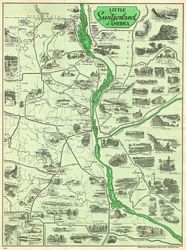
A splendid Piece of Work Advertising Clayton and Allamakee CountiesA fine piece of work has been issued, compiled by the Northeast Iowa Press association, with the travel bureau located at Elkader. J.A. Druyor of the Elkader Register, was chairman of the committee that issued the map and folder. It is entitled the "Little Switzerland of America." The work represented a great deal of detail and painstaking effort in compiling, the printing being done in a most artistic manner in colors. It was first planned to include Fayette and Winneshiek counties in this folder also, but lack of financial support made this impossible, hence the two Iowa counties and two across the river in Wisconsin make up the folder.
The map itself shows the rivers, the railroads, the highways of these four counties, and in addition to that are pictured some of the various attractions that may be seen at the various towns in these counties. It is surprising to note from the face of the map on which the scenes appear, how many wonders there are to be found in these two counties. Even old timers living here have forgotten a good many of them. Then on the reverse side of the map is a descripton of the beauties and wonders to be found. These descriptions include Marquette, McGregor, Postville, Strawberry Point, Edgewood, Elkader, Lansing, Waukon and guttenberg in Iowa, and Prairie du chien in Wisconsin. After a brief outline of the entire section the following points of interest are brought out from the various towns:Marquette - Pontoon bridge, scenic drive, Oakcrest, Indian Mounds, Old Military trail, Suspension bridge.
McGregor - Indians, Wild Life School, McGregor Heights, Pikes Peak, Pictured Rocks, Sand Art, Lotus Lillies, Boating, Aquarium, Bird Museum and Gold Course.
Postville - The Old Stone House, Trout Fishing and side trips.
Strawberry Point - Creamery, Backbone State Park, Joy Springs, Kleinlein Mill
Edgewood - Bixby State Park
Lansing - The Black Hawk bridge, Road of 1000 curves, Mt. Hosmer, Mt. Ida, Lovers Leap, palisades, Swedish Baptist church, Gabbitts Point
Waukon - The Iron Mine, Pinney Springs, Indian Mission Paint Rock
Monona - Beulah Falls
Guttenberg - Parked River Front, Government Locks, Pioneer Rock Church
Elkader - Native Stone Bridge, Scenic Drive, The Big Spring, Table Rock
Prairie du Chien - Fort Crawford, Trading Posts, Villa Louis, Churches and Cemeteries, Indian Village, College and Academy, Newlson Dewey State Park.Of course there are many more but these are the outstanding items mentioned. There are numerous scenes portrayed of varied interest. Everyone should secure a copy of this beautiful brochure, and it will aid them materially in picking out their Sunday drives and help to disseminate the information contained among their friends from a distance.
~*~*~
~source: Oelwein Daily Register, July 14, 1934
~contributed by Sharyl Ferrall for Allamakee co. IAGenWeb